El Rosal Cu-Zn Skarn
This was the first exploration project of the company and has seen drilling of nine holes in two campaigns in 2000 and 2004, which together with other data indicates the presence at depth of a porphyry (+ skarn) system. Panoro's conclusion has been that this project requires a substantial amount of deep drilling to fully test its potential and before a discovery can be made. In consideration of Panoro's current resources and priorities, the Company has decided that to seek a financially and technically strong joint venture partner for this project is the best option for this project at this stage.
La Ramada Polymetallic (Ag-Zn-Pb)
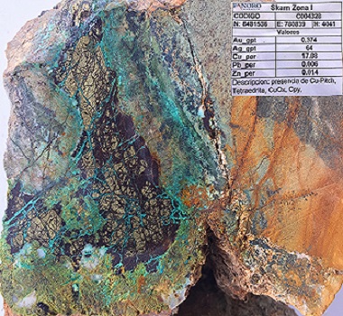
The silver-rich zinc-lead deposit is a carbonate replacement deposit (CRD) similar to deposits in Central Peru. It was intercepted approximately 200 meters of a porphyry copper mineralized intrusive. Both the CRD and the porphyry copper mineralization were discovered during the 2008 exploration program.
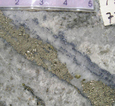
The CRD consists primarily of pyrite-sphalerite and minor galena and chalcopyrite that occur as veinlets, disseminations, and semi-massive to massive aggregates. The best intercepts range from 0.5m to 34.65m stacked roughly 20m apart starting from 208m from the surface. It has a cumulative thickness of 54.87m averaging 55.44g/t Ag, 3.95% Zn, 0.26% Pb with an 8.47m high grade zone averaging 111.54g/t Ag and 5.31% Zn.
The porphyry copper represents a separate exploration target. It is associated with pervasively quartz-sericite-pyrite altered with abundant quartz veinlets stockworks with grade of up to 0.42%Cu.
Luis Vela, P. Geo., Vice President of Exploration for Panoro and a "qualified person" under National Instrument 43-101, has reviewed and approved the scientific and technical information.
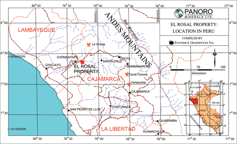
Quick Facts
| Location: | Northern Peru |
| Ownership: | 100% owned |
| Property size: | 5,700 hectares |
| Mineralization: | Gold-Copper |
| Status: | Exploration |
A Gold Copper Porphyry Project With Large Tonnage Potential
The El Rosal property in Lambayeque and Cajamarca Departments, northwestern Peru, is a porphyry Cu-Au prospect with related Cu-Zn-Ag and Cu-Au skarn mineralization. Panoro Minerals Ltd. has acquired a one hundred percent clear interest in the property since beginning work in 1998. It consists of eleven mineral concessions that encompass an area of fifty-seven square kilometres. The property is seventy-five kilometres east of the major city of Chiclayo at elevations ranging from 350 to 1300 metres with most of the area of interest between 400 and 800 metres. It is accessible by a main paved road from Chiclayo followed by some shorter earth roads to the east of the town of Chongoyape to the village of La Ramada.
Geology
The El Rosal property is underlain by Mesozoic sedimentary and volcanic strata, by Tertiary volcanic rocks, and by intrusive rocks of Early Tertiary age. The thickest of the carbonate units, the Pariatambo Formation, is >350 m thick and is composed of interlaminated limestone, felsic tuff and cherty siltstone. Stocks and sills of predominantly tonalitic composition, and probable Early Tertiary age, intrude the sequence, and are in turn intruded by porphyritic granitic bodies. Early Tertiary contractional deformation produced upright folds and thrusts that affect the entire lithologic sequence. Tertiary extension and strike slip faults with predominantly northwest trends are widespread in the area. The property area is structurally complex on a regional scale, reflected in an abundance of faults and fold patterns discordant to regional trends. It comprises a block that is bounded by north-south trending faults and east-northeast striking lineaments.
Targets
The El Rosal - Project is characterized by two principal targets with associated large tonnage potential, the El Rosal and La Ramada targets. The mineralized systems identified by Panoro's work represent a new discovery of this type of system in this area of northern Peru.
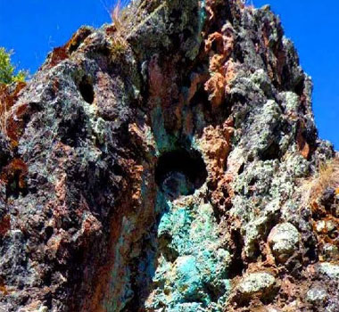
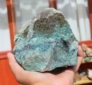
The El Rosal target contains copper - zinc - silver mineralization of a type called "skarn" mineralization, hosted by >350 m thick interlaminated limestone, felsic volcanic tuffs and cherty siltstones overlying and intruded by tonalite (quarzdiorite) intrusive bodies, associated "endoskarn" and, significant for its tonnage potential, porphyry style alteration/mineralization, as well as polymetallic veins. The largest showings on the property and on this target, the El Rosal and Zona Central showings form the exposed portions of a 50-200m thick contact aureole above the El Rosal stock.
Within the El Rosal-Zona Central system, copper, zinc and silver mineralization occur. The most significant mineralization occurs in the El Rosal showing, where representative surface sampling has commonly returned values >1% combined Copper + Zinc over widths ranging from 1-3 m to >10 m. Significant Copper and Zinc grades (>0.2%) occur disseminated and in veinlets within bands immediately above the top of El Rosal stock as well as within in the upper portions of the stock. While continuous intersections of potentially economic mineralization were not identified during the first drilling program in 2000, it had tested only a small part of the northwestern parts of the system.
Of significance for the large tonnage potential is the fact that the El Rosal stock underlying the El Rosal and Zona Central showings is affected by porphyry and calc-silicate style alteration with associated anomalous copper - molybdenum mineralization. Surface exposures, dimensions of an associated geophysical Induced Polarization chargeability anomaly, and exposures of a showing 1 km to the east that is probably contiguous with the system, the Calabozo showing, suggest minimum dimensions of the intrusion and associated mineralization/alteration system of approximately 2.5 km long by 2 km wide. Peripheral veins form an outer lead-zinc zone that is consistent with, and may expand, the overall dimensions of the system.
On the second target, the La Ramada Copper-Gold target, three other skarn showings, Calabozo, La Ramada and La Ramada Sur, have been identified 1-2.5 km to the east of the El Rosal and Zona Central showings. Surface exposures of these are smaller than the El Rosal-Zona Central system, although their extent has not been fully defined. These also occur in the limestone-tuff-siltstone formation present at El Rosal and are spatially associated with intrusive "tonalite" (quartz diorite) sills and dykes similar to those at the El Rosal target . Significant copper and zinc grades (1-3%), and in this case also anomalous gold concentrations (ranging from less than 1 gram/tonne to greater than 1gram/tonne over 5m width and locally exceeding 5 grams/tonne) have been obtained from rock chip and channel samples from all three showings. Several significant and unexplained gold. e.g. 178 and 138 ppb (100ppb = 0.1 gram/tonne) gold and anomalous copper stream sediment sample results have also been obtained from this area. The showings and anomalous geochemical values in this area may be associated with a distinctive intrusive center that is similar to, but separate from, the El Rosal Stock. Work in 2003, consisting of additional geochemical and geophysical surveys outlined a 800 x 1200 m Induced Polarization anomaly in the southern part of the La Ramada area, supported by anomalous gold values in soils and anomalous copper values in stream sediments.
Results of the 2003/04 exploration campaign
The aim of the 2004 drill program was to test the El Rosal target for a "blind", unexposed zone of economic mineralization to the south of the drill holes of the year 2000 under an overlying rock cover.
The exploration programs of 2003 and 2004 were aimed at two principal targets.
The El Rosal target, which had seen a seven holes drill program in 2000, was explored by two additional drill holes which were in part reported on in an earlier news release.
Drill hole ER08-04 (270m) was aimed at a deep Induced Polarization anomaly in the southeastern part of the target as presently defined. After passing through wollastonite garnet skarn it entered the intrusive at 51.5m. Sections of the hole are anomalous in copper and zinc. The intrusive in this drill hole exhibits weak propylitic alteration. A quartz epidote chalcopyrite vein/fault was intersected at 154.3m, assaying 1.17% copper over 3m or 0.84% copper over 5.74m. The hole is located at the fringe of the target.
Drill hole ER09-04 ((349m) is located 550m east of year 2000 drill hole ER02-00 and 550m south east of ER04-00. It is a step out from the more felsic sections of the El Rosal stock along the El Rosal anticline and was aimed at the centre of the stock where a cluster of quartz epidote chalcopyrite (copper) veins were cutting through the rocks hosting the intrusive. While the top of the intrusive stock was intersected at elevations of 520m in ER02 and 650m in ER04, drill hole ER09-04 was still in highly siliceous calc silicate hornfels and skarn at the end of the hole (349m) at an elevation of 525m. Prior to reentering hornfels the drill hole intersected 41m of an intrusive section with anomalous values in copper and molybdenum. The hornfels/skarn is highly anomalous in zinc (and copper) from 279.9m to 296.6 m above the contact with the intrusive. (0.6% zinc over 16m, including 2.69% zinc over 2.35m). The significance of the alteration and mineralization lies in its indication of a strong system below it. A very strong and thick (220m) hydrothermally altered thermal aureole of hornfels and calc silitate-wollastonite skarn was intersected in ER09-04.
In conclusion the results of the two drill holes on the El Rosal target indicate the continuation and strengthening of the system to the south of drill holes ER02 and ER04 of the year 2000, albeit at greater depth below surface and beyond the capacity of the man portable drills that were used in this campaign.
At the La Ramada target geological, geochemical and geophysical surveys carried out in 2003 led to the definition of several drill targets that were tested in 2004. The drill program was accompanied by further detailed geological mapping with specific attention to structural complexities. Mapping and surface sampling at the La Ramada and La Ramada Sur occurrences confirmed the strong gold component of this mineralization with a thickness of up to 15m. The strike length of the La Ramada Zone is indicated to extend over 200m with a possible fault limiting it to 300m.
Results of Surface Channel Sampling at La Ramada and La Ramada Sur
| Zone | % Copper | Grams/tonne gold | Grams/tonne silver | True width meters |
|---|---|---|---|---|
| La Ramada | 1.6 | 0.38 | 19 | 5.5 |
| including | 2.14 | 1.0 | 26 | 2.0 |
| La Ramada | 1.0 | 0.2 | 16.8 | 8 |
| La Ramada Sur | 1.0 | 0.53 | 3.85 | 7.0 |
| including | 1.0 | 1.5 | 5.37 | 4.5 |
The La Ramada Sur showing occurs on the western slope of the mountain ridge forming the La Ramada Target. The eight east - west streams draining this slope into the main Calabozo drainage are all clearly anomalous in copper values in stream sediments over an north - south distance of over two kilometers. Source of this anomaly may be a diatreme breccia zone that has been traced from the Ramada Sur showing south in intermittent outcrops over a distance of 700 meters with widths ranging from 50 to 100 meters. This breccia and the northern extension of the Ramada Sur showing represent a new exploration target on the project.
The La Ramada target was tested in four drill holes of which one had to be abandoned when the drill sting broke and got stuck in a fault zone. The northern part of the target was explored by RA01-04 and RA02-04(abandoned). The objective of the holes was to test the area between the La Ramada and La Ramada Sur showings at depth and at their contacts with the underlying intrusive.
Drill hole RA01-04, aimed at the area between the La Ramada and La Ramada Sur showings intersected short high grade sections of copper and copper - zinc mineralization contained in an intrusive diatreme like breccia ( 21.10m to 46.05m) as indicated in the Company's news release of March 24, 2004. This was the first time that this rock type has been encountered on the property. A short assay interval within the breccia, representing a breccia fragment from a mineralized zone at unknown depth, assayed 3.1%copper, 12.25% zinc and 48.6 grams silver/tonne over 0.7 meters. A second interval of intrusive breccia and adjoining skarn assayed 0.57% copper over 6.0 meters, including 1.0% copper and 14.6 grams silver/tonne over 2.65 meters. The carbonate rocks above the intrusive section at the bottom of the hole exhibited moderate hydrothermal alteration from 52 to about 166 meters depth, with increasing wollastonite and garnet contents and became strongly altered from 166 to 310.75 meters, when the hole entered a dioritic intrusive at the bottom of the hole at 340.45meters. Anomalous copper values in the range of 0.15% to 0.4% and anomalous zinc values in the range of 0.2% to 0.98%were encountered over intervals from less than 1meter to over 6 meters scattered over the more intensely altered sections of the hole.
Drill hole RA02-04 did not reach target depth and was abandoned as indicated above.
Detailed surface mapping around the La Ramada and La Ramada Sur showings revealed steep dipping structural controls at both showings. The strike -, as well as the down dip extensions of both showings to their inferred contact with the underlying intrusive, represent further drill targets.
Drill hole RA03-04 and RA04-04 were aimed at testing the strong (24-34 mV/V) and extensive Induced Polarization (IP) anomaly in the southern part of La Ramada outlined by the 2003 geophysical survey. The IP-anomaly was in its western portion supported by geochemical anomalies in soil for gold, lead, zinc, bismuth and arsenic and for copper in stream sediment samples. RA03-04 (277.85 meters) intersected a sequence of lime-stones and shales alternating with sills of diorites and intrusive breccias. High contents of pyrite and pyrrhotite appear to be responsible for the IP-anomaly. The drill core was strongly anomalous in zinc content between 94 meters and 259 meters, with narrow veins of lead, zinc, silver and lesser gold mineralization at 236 meters and 251meters. Indications in the drill hole and from detailed surface mapping indicate that the geochemical response on surface may come from a faulted off block of ground to the west of the drill hole. RA04-04 (220.7 meters) intersected a post mineral feldspar porphyry dike from about 74 to 180 meters. The sulphide content in the entire hole was low, indicating that the drill hole did apparently not test the IP-anomaly.
At this stage the exploration on the El Rosal project was halted to allow receiving the assay results for all drill hole and surface samples and to review the results in conjunction with new information and data obtained in a simultaneous detailed geological/structural surface mapping program.
As a result of the final review management has concluded that the project remains to be one with large tonnage potential. The breccias discovered in the 2004 campaign represent a new target and should be subject of initial surface exploration by trenching and possibly shallow drilling.
While it is expected that other targets will be identified on this Project, Panoro's conclusion has been that this project requires a substantial amount of deep drilling to fully test its potential and before a discovery can be made. Considerations of prudent management of risk and of Panoro's current resources and priorities have led the Company to the decision to seek a financially and technically strong joint venture partner for this project. Discussions with potential joint venture candidates have been ongoing for some time.